


- The Great Cornwall Guide
- Destinations

- Things to do

- Beach Guide

- Food & Drink

- Properties

- Journal

- Golden Lobster Reviews

- Destinations
Learn about Cornwall’s mining history through scenic walks and designated mining heritage trails, explains Kirstie Newton.
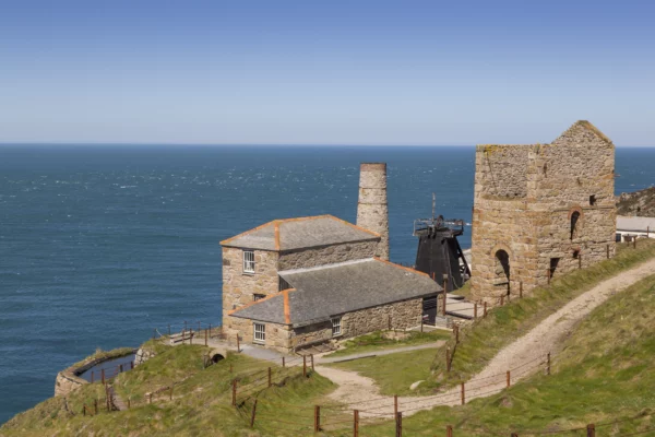
At its 19th-century peak, Cornish mining employed more than 30,000 people, encouraging an eager workforce to settle in towns and villages that still exist today. But when the industry began to decline, thousands left Cornwall to find work overseas as Cousin Jacks, leading to Cornish surnames and pasties in lands as far afield as Australia, Mexico and South Africa. The ruined remains of engine houses are now a romantic reminder of an industrial past, protected by law as a Unesco World Heritage Site (WHS). You can walk or cycle along the remains of railways and tramroads while considering the hard graft that took place here 200 years ago. Here is a selection of trails, many of which can be reached by train.
Where? Redruth
How long? 7.5 miles
Suitable for: Cyclists, horse riders, walkers – pushchair-friendly
Cornwall’s mining heartland, around Redruth and Camborne, was once described as “the richest square mile in the world”. Today its former tram and railroads form a 37.5-mile network of multi-activity trails. The Great Flat Lode is a circular route sweeping around brooding Carn Brea, and takes its name from a rich vein of tin ore laid more horizontally than most. The trail follows part of the line of the Basset Mine Tramway, built to carry tin ore from the mines to Wheal Basset Stamps for processing. As you pass through peaceful farmland and heathland, it’s hard to imagine that this whole area would once have been dirty and noisy with industry, the sheer scale of which led to major population growth – hence the urban sprawl beneath you (climb Carn Brea for the best views).
While you’re here: Others trails nearby include Tehidy, Tresavean and Wheal Peevor. Alternatively, visit a historic mine such as East Pool (National Trust) or King Edward Mine Museum in Troon (reopens for the season in April). Younger family members will love Heartlands, with its outdoor play park.
How long? 2.5/4 miles
Suitable for: Walkers
Get here: The branchline from Par to Newquay stops at Luxulyan, and the valley is within walking distance of the station.
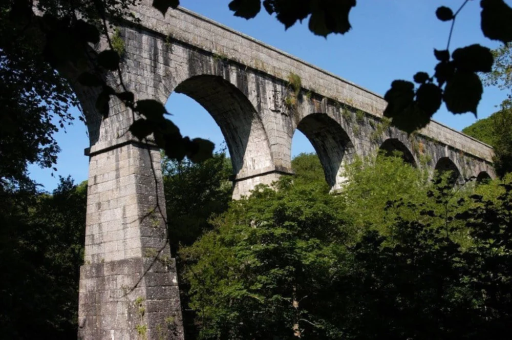
The Luxulyan Valley was a transport hub for local industry in the 19th century, thanks to the presence of the Par River, which flows down to St Austell Bay. Extensive leats provided water essential for sluicing Charlestown Harbour and powering machinery at the Fowey Consols copper mine. The man who harnessed its potential was landowner and entrepreneur Joseph Thomas Treffry (1782-1850), who enabled the successful exploitation of the area’s valuable mineral resources – copper ore, granite and china clay; and gave his name to the majestic granite viaduct which carries both a leat and tramway route high above the valley. It’s now a Scheduled Ancient Monument, managed by Cornwall Heritage Trust. This tranquil woodland setting is especially appealing in spring, when the floor is carpeted with bluebells.
While you’re here: Wheal Martyn China Clay Museum, near St Austell, gives a fascinating insight into Cornwall’s important billion-pound china clay industry, including a breathtaking view into a modern working clay pit.
Devon Cornwall Rail Partnership
Where? Tamar Valley
How long? 87 miles, from the source of the Tamar to its mouth at Plymouth – choose your stretch!
Suitable for: Walkers
Get here: Take the branch line to Calstock.
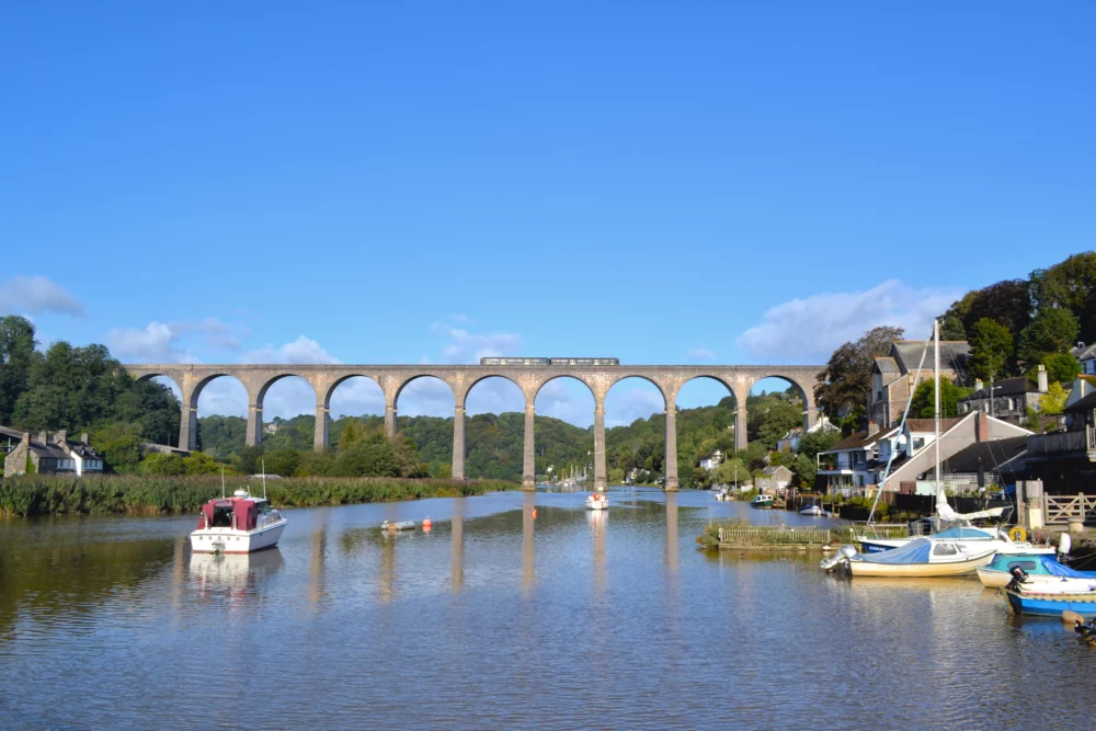
The Cornish Mining World Heritage Site (WHS) includes both sides of the Tamar Valley, where over 100 mines operated at the height of its mining boom. Tin, copper, silver-lead and arsenic were all found here, and you can still find evidence of their workings. A good place to start is Calstock – tranquil and pretty, with a truly magnificent viaduct carrying the railway over the Tamar. Follow the river west towards Gunnislake, and you’ll find the ivy-clad ruins of Okel Tor Mine – in its heyday a thriving tin, copper, lead and arsenic mine, today a Scheduled Ancient Monument and a 16-acre woodland wildlife haven. You can even stay in the Grade II listed Count House and Smithy.
While you’re here: The National Trust property of Cotehele, with its Tudor house and Victorian quay, is within walking distance of Calstock. In the car? Across the river on the Devon side is Morwellham Quay, a historic river port developed to support the local mines, now run as a tourist attraction and museum.
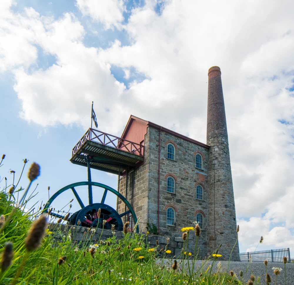
Michell's Engine House, East Pool Mine, Cornwall ©National Trust Images Hilary Daniel
How long? 24 miles
Suitable for: Cyclists
Get here: Hayle is on the main Penzance-to-Paddington railway line.
From the remains of the Harvey’s Foundry in coastal Hayle to the engine houses scattered throughout the West Cornwall landscape, the reminders of Cornwall’s industrial heritage are everywhere along this long-distance route. During the 19th century, Hayle became the most important foundry in the world for making Cornish engines and boilers, employing engineers and designers like Richard Trevithick, and building the largest steam pumping engine ever built. Leaving the golden sands behind, this trail follows quiet minor roads and traffic-free trails to join the Mineral Tramways around Camborne and Redruth, through the small mining village of Carharrack, along the Redruth and Chasewater Railway Trail and over to Bissoe before ending in the cathedral city of Truro. Break the trail into sections by cycling between railway stations.
While you’re here: Hayle Heritage Centre on the historic foundry site re-opens in 2024 with a new exhibition: Hayle Herstory, sharing the untold stories of some of West Cornwall’s remarkable women. And make lunch a Philp’s pasty, eaten overlooking Copperhouse pool.
Where? Devoran to Portreath
How long? 11 miles
Suitable for: Cyclists, walkers
Get here: There is parking at Portreath, although it gets busy in summer; parking, bike hire and café at Bissoe. Alternatively, take a bus to Devoran from Truro or from Redruth for Portreath.
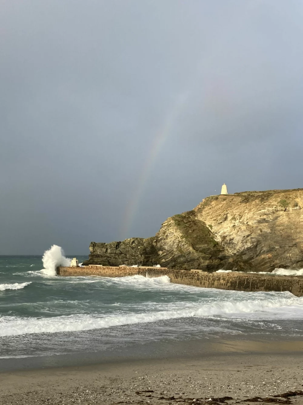
The Coast-to-Coast Trail connects the south coast river port of Devoran, on the Fal, to the Atlantic harbour village of Portreath. During the 19th century, both served the rich copper and tin mining industry in the triangle between Truro, Falmouth and Redruth – including hardy villages such as Scorrier, St Day and Twelveheads. Many bear huge Methodist chapels which attest to the population they once supported, now replaced by spectacular natural beauty. The trail follows two historic routes: Portreath tramroad (1812) and Redruth & Chasewater Railway (1825). Allowing for at least a couple of hours each way, this is a trail you can do in a day, with bike hire at both Portreath and Bissoe.
While you’re here: Take your swimming gear and go for a dip in Portreath – remember, wetsuits are for sissies! Reward yourslf with fish and chips and/or an ice cream.
Where? Liskeard
How long? 17 miles (can be split into two shorter loops)
Suitable for: Cyclists, walkers
Get here: You can reach the trail from Liskeard railway station.
Copper is at the heart of the mines on this south-eastern fringe of Bodmin Moor. South Caradon Copper Mine was the largest in the UK in its heyday ; Phoenix Mines and Gonamena Incline are also evidence of the explosion of activity here. But it was to last just 50 years, and was done and dusted by 1890. The landscape here is now wide open moorland – look out for livestock – and studded with ancient monuments, including The Hurlers stone circles, the gravity-defying Cheesewring, King Doniert’s Stone and Trethevy Quoit. Deep river valleys mean the occasional sharp incline.
While you’re here: The market town of Liskeard is worth a visit – especially the museum and historic Stuart House – and from here, you can take the branchline to jolly seaside town Looe.
Where? St Agnes
How long? Depends on where you park and how far you want to walk!
Suitable for: Walkers
Get here: Council car park at Trevaunance Cove, National trust car parks along the coast.
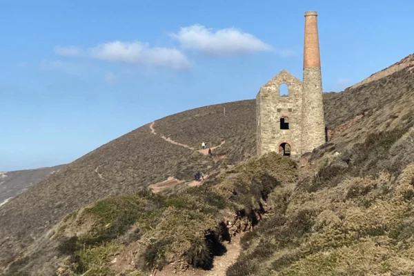
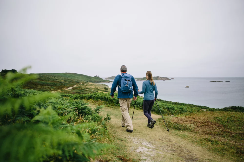
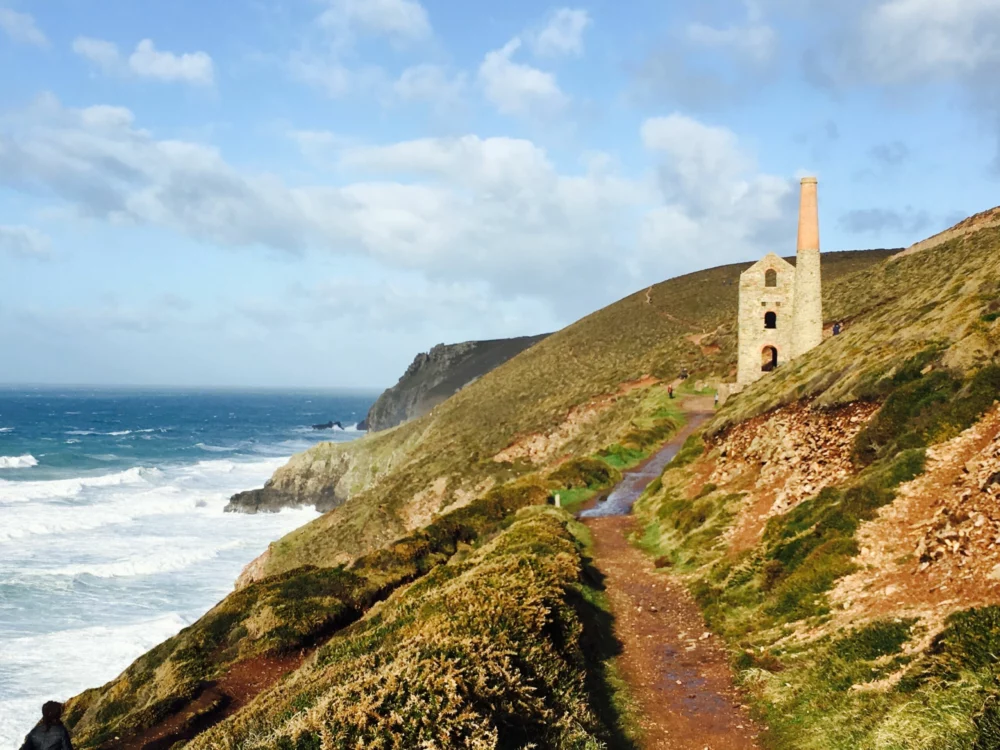
Is there a scene more iconic of Cornwall than that of Towanroath Shaft engine house, clinging to the cliff edge on the Atlantic coast? It’s surely one of the most photographed mine buildings in the country, and is part of the Wheal Coates complex, which was worked from 1802 to 1889. The South West Coast Path passes through here, meaning there’s a constant gaggle of hikers, families and photographers. Drop a stone down the covered mine-shaft and time how long to takes to hit water; now imagine what it would have been like to work underground. Romantic as it seems now, this was a dirty and dangerous job, with risk of ill health and accident – most miners were worn out by the age of 40.
While you’re here: Extend your walk to climb St Agnes Beacon for superlative views along the North Cornwall coast and over towards Carn Brea. Sink a pint at the Driftwood Spars in Trevaunance Cove, or indulge in a “hedgehog” – vanilla ice cream rolled in clotted cream and toasted nuts – at Chapel Porth.
Categories: Arts & Heritage, Cornwall Walks, Trips & Tours in Cornwall